Click on thumbnails to see full size images
 Paris walls Paris' development has been strongly influenced by the walls and other barriers that have surrounded it since its founding. |
 Paris and its Walls |
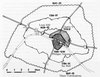
 Paris in mid-1500s. Notice the N/S orientation of the city (the Seine runs E/W), a prospect that would change in the mid-17th c. |
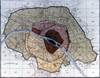
 The Marais district, 17th c. Notice the Bastille's prominence in this map (upper center). |
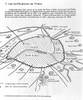
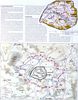
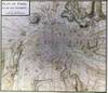 Paris & its environs in the early 18th c. |
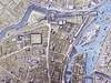
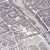 Turgot, Louvre and Tuileries (1739) |
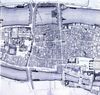 Delagrive, Île de la Cité (1754) |
 Plan Verniquet (fin du XVIIIe sičcle) |
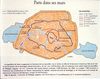
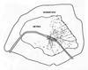
 Thiers fortifications (1841-45) These were the last defensive walls built around Paris. |
 June 1848 Barricades Notice that they were in the East of Paris. |
 Haussmann's Paris Imagine the amount of work, by steam engine and manpower, that had to build all the areas in orange. |
 Paris of Napoleon III This hand-drawn map picks out the major architectural changes made by Napoleon III and Haussmann. |
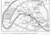
 The Seige of Paris (1870-71) These images show how Paris was surrounded by the Prussians (Sept-Jan), then what the Communards burned in their retreat toward the N.E. of the city (May) |
 Lévy 1900 (in Herbert) This map shows Paris c. 1900. |
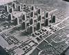 Paris, Corbusier plan A plan never implemented, but with a "modernist" emphasis on sky-scrapers. |
 Paris, map with monuments A typical map that seeks to "touristize" Paris. |
 The Grands Travaux (Major Projects) of Mitterrand |
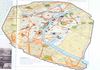
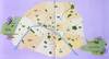
 13e Arrondissement A recent example of how a run-down area of Paris will be re-developed. |
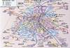 Paris Metro Map One of many examples, the map shows a different way of understanding Paris. |
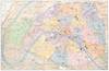
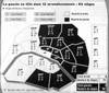
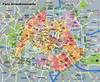 Paris Arrondissements A good image of how Paris is divided administratively. |
 Paris Green Spaces Very few for such a large city (esp. if one discounts the two large parks on the extremities, Boulogne and Vincennes). |
 Paris, 2000 Elections How Paris voted, with the Left being the darker color. |
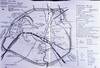
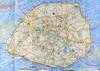
 Paris Projects, Le Parisien (2001) A fantastic image of plans Paris should consider in order to make it easier to live in, including a trans-urban underground highway. |
 Paris: Histoire du Ville (1993) An overview of Paris showing its main arteries. |
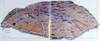
 Paris (satellite view) |
||